Vision
Preserving and visualising hidden histories of Jerusalem
Our understanding of day-to-day life in late-Ottoman Jerusalem remains incomplete.
The Virtual Illés Initiative is a pioneering digital humanities project that aims to compile historical records and facilitate universal access to uncovered facets of Jerusalem.
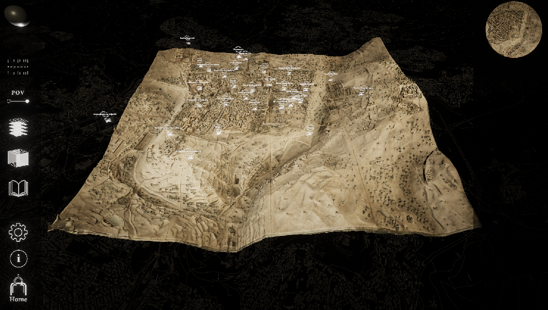
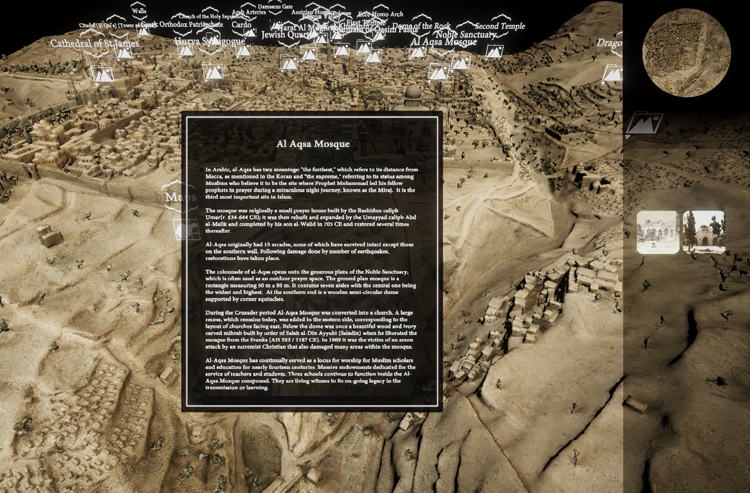
The project focuses on the Illés Relief (1873), a remarkable miniature model that depicts the Old City and the developing New City at the time of its fabrication.
Stephan Illés (b. 1839), who arrived in Jerusalem in 1864 from Pressbourg (now Bratislava, Slovakia), is our pre-eminent guide to late-19th-century Jerusalem. A book-binder by trade, he had a keen eye for detail and a good understanding of how three-dimensional objects are constructed, as well as a passion for meticulous craftsmanship.
In contrast to classical two-dimensional cartography, the Illés Relief (scale 1:500 – roughly 15 by 16 feet or 4.5 by 5 meters) was constructed in 3D from zinc sheets and mounted on a frame built in eight modular units to facilitate its transportation and display.
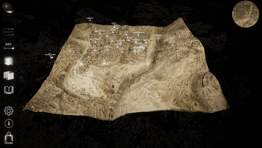
This invaluable historical record has been digitally reconstructed to produce an information-dense and highly interactive resource accessible to international scholars and the global public alike.
Features
The Virtual Illés Initiative is a bespoke immersive mapping system that allows multimedia content to be embedded within a digitized Jerusalem. It features a range of modular interactive tools that can be deployed on desktop, VR, and immersive museum systems.
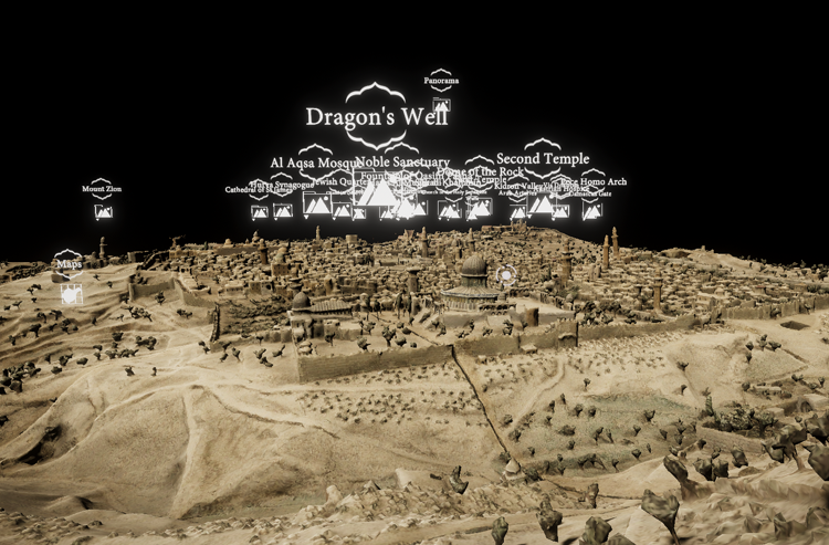
Detailed 3D world
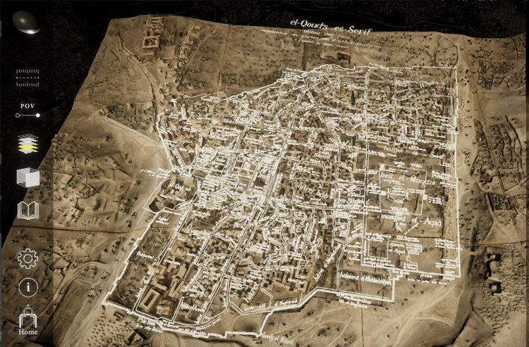
Historical map overlays
Interactive archive
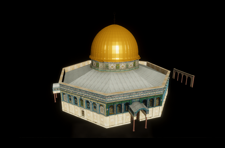
Interactive 3D models
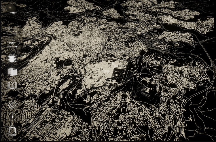
Immersive GIS mapping
App Download

Download the PC app for free on STEAM.
Contact us directly for other platforms, including museum displays.
The Virtual Illés Team
Project Director
Dr Maryvelma O’NeilFounder and Director, Alliance to Revitalize Cultural Heritage in Jerusalem (ARCH)
Immersive Director
Dr Andrew YipLecturer, Immersive Design, Sydney
Advisers
Dr Yuval Ben Bassat, University of HaifaDr Johann Büssow, University of Bochum
Dr Michelle U. Campos, Pennsylvania State University
Mr Chandler Collins, Bar Ilan University, Ph.D. candidate
Dr Heather Ferguson, Claremont McKenna College
Dr Roberto Mazza, Executive editor, Jerusalem Quarterly, Independent scholar
Dr Falestin Naili, University of Basel
Dr Issam Nassar, Illinois State University
Eng. Hamza Sarraj, Zamakan
Dr Yair Wallach, SOAS University of London
Collaborate with us
The Virtual Illés Initiative is an interactive and immersive reconstruction of The Illés Relief (1873), a remarkable miniature model that depicts the Old City of Jerusalem and the developing New City at the time of its fabrication. It is a pioneering digital humanities project that aims to complete historic records of nineteenth-century-Jerusalem within an interactive virtual environment.
Since its inception in 2019, the Initiative has been conceived to incorporate crowdsourced content from researchers and citizen scientists of all cultural backgrounds – thus, the platform allows for mobile spectatorship as well as two-way knowledge mobilisation whereby spectators can also contribute to the knowledge base about and for the virtual relief. It was envisaged that an international team of Ottomanists, Jerusalemite historians, sociologists, economists, local NGOs, students, members of ethnic communities, the Palestinian diaspora, and others would contribute multivocal content that represented the diverse cultural experiences of the Old City extending the scope of the project from late Ottoman Jerusalem to the present.
The very act of mapping Jerusalem, the occupied Palestinian territory, or Israel are contested political actions with implications for Palestinian and Israeli borders. In this regard, access to knowledge is fought over unequal terrain; Quiquivix (2014) has documented efforts by Palestinian refugees to remap unacknowledged or erased sites of Palestinian heritage onto Google Earth maps via grassroots participation. These are acts of counter-cartography that maintain cultural claims in the face of the dominant borders of nation states. Clearly, there is great political power in making these layers of knowledge globally visible
The Virtual Illés Initiative is an evolving collaborative project and we welcome contributions from scholars, researchers, students and citizens. We invite you to contribute new documentation and artifacts, other elements of intangible culture, personal glimpses of the living city and memorabilia including diaries, letters, memoirs, and photographs. These contributions will be used to annotate and animate the virtual relief, and to challenge conventional historiographical views of Jerusalem.